Heritage Sites

The five Castles of Mount Amel

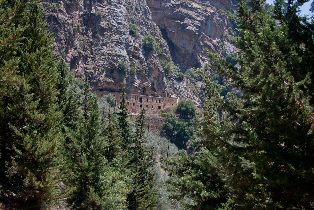
Tentitive Sites The five Castles of Mount Amel Across the hills of Mount Amel, a chain of fortresses stands as a testament to centuries of strategic control, conflict, and architectural evolution. Historical Significance The Five Castles of Mount Amel form a coherent defensive network reflecting the military, political, and architectural dynamics of southern Lebanon from antiquity through the medieval period. Primarily developed during the Crusader era and subsequently adapted by Ayyubid, Mamluk, and later powers, these fortresses illustrate the exchange of defensive techniques and the evolution of fortified architecture. Positioned along strategic ridges and routes, they collectively demonstrate how control over territory was asserted and maintained across centuries in a region of sustained geopolitical importance. About the Serial Property Located across South Lebanon, the five castles occupy elevated and strategic positions overlooking key valleys, trade routes, and agricultural landscapes. Though each site has its own distinct history and condition, together they form an interconnected system of fortifications that reflect both regional defense strategies and local adaptations to terrain. Their distribution across Mount Amel highlights the importance of topography in medieval military planning and territorial control. Components of the Property Qalaat al-Chakif (Beaufort Castle): Built in the 12th century around 1137, this fortress dominates the Litani River valley from a strategic ridge. It is one of the best-preserved medieval castles in the Near East and was expanded by Ayyubid, Mamluk, and later rulers. Qalaat Tibnin (Toron Castle): An early 12th-century Crusader stronghold situated on a hilltop, preserving archaeological layers dating back to the Bronze Age. Its successive modifications reflect continuous adaptation of defensive architecture. Qalaat Chakra (Dubieh Castle): Located along a southern Lebanese ridge, this Crusader-era fortress overlooks a landscape of agricultural terraces. Despite partial ruin, it retains clear structural features and defensive planning. Qalaat Deir Kifa (Maron Castle): Positioned on elevated terrain, this former Crusader military post was later reused by regional powers. It preserves layered remains demonstrating prolonged occupation and strategic reuse. Qalaat Chama’: Situated near the Mediterranean coast, this hilltop fortress dates back at least to the Roman period and was reinforced during the Crusader era. It remains a symbol of continuous historical use despite modern conflicts. Cultural and Strategic Context Together, these castles represent more than isolated monuments—they form a broader cultural and military landscape shaped by conflict, adaptation, and continuity. Their enduring presence reflects the strategic importance of Mount Amel as a frontier zone, where successive powers left their mark on both the architecture and the territory. As a group, they illustrate the transmission of military knowledge and the lasting imprint of fortified systems in the eastern Mediterranean. Open User Map This block will show your Locations on a map in the front end. Custom Map Position (optional): Latitude Longitude Zoom Filter Locations (optional): Filter by Marker Categories [PRO] Filter by POST IDs Witness damage or threat to this site? Report it immediately. Report Damage Report

The five Castles of Mount Amel Read More »

Ras Al-Qalaat, Al-Natour, and El-Mlelih Promontories

Tentitive Sites Ras Al-Qalaat, Al-Natour, and El-Mlelih Promontories At Anfeh, the coastline is not only shaped by nature, but by centuries of human ingenuity, carving livelihoods directly into the rock. Historical Significance The promontories of Ras Al-Qalaat, Al-Natour, and El-Mlelih form an exceptional coastal cultural landscape that reflects continuous human interaction with the Mediterranean environment over millennia. Evidence of occupation extends back to the Chalcolithic period, with successive Phoenician, Byzantine, and Crusader influences shaping the site. The area is particularly notable for its rock-carved salt pans—among the oldest in the Mediterranean—which demonstrate the long-standing development and transmission of maritime production techniques. Archaeological remains, including wine presses, religious structures, and fortified elements, further illustrate the diversity of activities that defined the site across time. About the Site Located in northern Lebanon in the region of Anfeh and its extension Hraishi, the site is composed of three interconnected promontories: Ras al-Mlelih, Ras al-Qalaat, and Deir al-Natour. Each area contributes distinct features, from archaeological remains and medieval fortifications to extensive salt marshes carved directly into the coastal rock. Deir al-Natour, in particular, hosts the largest concentration of salt pans in Lebanon, surrounding a Crusader-era monastery built upon earlier Byzantine foundations. The physical layout of the site highlights a close relationship between land, sea, and human activity. Cultural and Environmental Interaction This landscape represents a rare example of sustained adaptation to a coastal environment, where natural resources were harnessed through innovative techniques that have endured across generations. Salt production, maritime trade, and religious practices coexisted within a single setting, creating a dynamic and multifunctional space. Today, the site remains a powerful testimony to the resilience and ingenuity of coastal communities, illustrating how cultural traditions can be deeply rooted in and shaped by the natural environment. Open User Map This block will show your Locations on a map in the front end. Custom Map Position (optional): Latitude Longitude Zoom Filter Locations (optional): Filter by Marker Categories [PRO] Filter by POST IDs Witness damage or threat to this site? Report it immediately. Report Damage Report

Ras Al-Qalaat, Al-Natour, and El-Mlelih Promontories Read More »

Sacred Mount Hermon and its Associated Cultural Monuments

Tentitive Sites Sacred Mount Hermon and its Associated Cultural Monuments Rising above the region, Mount Hermon has long been a place where earth and sky converge, shaping one of the most enduring sacred landscapes of the Near East. Historical Significance Sacred Mount Hermon has been revered since the Bronze Age, holding a central place in the spiritual and cultural traditions of the Near East. Referenced in ancient texts and associated with key biblical narratives, the mountain has attracted successive civilizations, including Canaanite, Roman, Christian, Islamic, and Druze communities. The presence of over thirty temples and shrines, many situated at high altitudes, reflects a long-standing tradition of ritual practice and pilgrimage. These remains illustrate not only continuity of worship but also the exchange and adaptation of religious beliefs across cultures and time. About the Site Located in southern Lebanon along the Syrian border, Mount Hermon rises to 2,814 meters, dominating the surrounding landscape. Its archaeological remains are dispersed across its slopes and summits, with notable sites such as the sanctuary of Qasr Antar marking some of the highest places of worship in the region. The positioning of these structures highlights the symbolic importance of elevation, where proximity to the sky reinforced the mountain’s sacred character. Spiritual and Cultural Landscape Mount Hermon is best understood as an evolving cultural landscape rather than a single archaeological site. Its significance lies in the continuous layering of spiritual meanings attributed to it by different communities over millennia. The coexistence of diverse religious traditions, all connected to the same natural landmark, underscores its role as a shared sacred space. This enduring spiritual relevance, combined with its dramatic natural setting, makes Mount Hermon a powerful testament to the intersection of nature, belief, and cultural identity. Open User Map This block will show your Locations on a map in the front end. Custom Map Position (optional): Latitude Longitude Zoom Filter Locations (optional): Filter by Marker Categories [PRO] Filter by POST IDs Witness damage or threat to this site? Report it immediately. Report Damage Report

Sacred Mount Hermon and its Associated Cultural Monuments Read More »

The Historic Centre of the City of Batroun

Tentitive Sites The Historic Centre of the City of Batroun In Batroun, the city and the sea are inseparable, shaping a coastal landscape where history has been carved directly into stone. Historical Significance The Historic Centre of Batroun reflects a long and continuous history of occupation dating back to the Early Bronze Age. Successive civilizations—including Phoenician, Roman, Byzantine, Crusader, Mamluk, and Ottoman—have contributed to its layered urban and architectural identity. Among its most distinctive features is the Phoenician sea wall, carved directly into the coastal rock, alongside remains of Roman, Crusader, and later structures. This accumulation of heritage illustrates the evolution of a Mediterranean coastal settlement shaped by trade, defense, and maritime activity. About the Site Located approximately 54 km north of Beirut, Batroun sits on a rocky promontory overlooking the Mediterranean. Its historic centre is characterized by a compact urban layout with narrow streets, traditional souks, and sandstone-built houses that reflect its Ottoman-era fabric. Key elements include the unfinished Roman theatre, Crusader fortifications, and remnants of ancient port installations. The spatial organization of the city reveals its defensive origins while maintaining a strong connection to the sea. Cultural and Contemporary Relevance Batroun’s identity is deeply rooted in its relationship with the Mediterranean. Maritime traditions, including fishing and historical sponge harvesting, have played a central role in shaping both its economy and cultural practices. The enduring use of coastal resources, combined with the preservation of historic urban forms, makes Batroun a compelling example of continuity in coastal land use and community life across millennia. Open User Map This block will show your Locations on a map in the front end. Custom Map Position (optional): Latitude Longitude Zoom Filter Locations (optional): Filter by Marker Categories [PRO] Filter by POST IDs Witness damage or threat to this site? Report it immediately. Report Damage Report

The Historic Centre of the City of Batroun Read More »

Temple of Eshmun

Tentitive Sites Temple of Eshmun At Eshmun, water, architecture, and belief converge to form one of the most enduring sacred landscapes of the ancient Mediterranean. Historical Significance The Temple of Eshmun is one of the most important Phoenician religious complexes in the Levant, dedicated to Eshmun, the god of healing. Established in the late 7th century BC, the sanctuary evolved continuously over nearly a millennium, reflecting successive cultural influences from Phoenician, Persian, Hellenistic, Roman, and Byzantine periods. Its architectural layers—including monumental podiums, decorated temples, and later religious structures—illustrate the transformation of sacred space across civilizations while preserving its original spiritual function as a center of healing and pilgrimage. About the Site Located near Sidon on the southern bank of the Awali River at Bqosta, the sanctuary extends across approximately 3.6 hectares within a naturally rich setting. The complex includes a sequence of terraces, ritual basins, sacred pools, and processional pathways, all closely integrated with water sources that were central to its healing rituals. Sculpted friezes, architectural remains, and the later addition of a Byzantine church highlight the site’s architectural richness and its continued importance across different periods. Spiritual and Cultural Context The significance of Eshmun lies in its role as a healing sanctuary where water, ritual, and belief were inseparable. The integration of natural springs into the sacred architecture reflects ancient conceptions of purification and renewal, attracting worshippers over centuries. Its long continuity of use demonstrates how sacred traditions were adapted rather than replaced, making it a powerful example of spiritual resilience and cultural transformation within a single site. Open User Map This block will show your Locations on a map in the front end. Custom Map Position (optional): Latitude Longitude Zoom Filter Locations (optional): Filter by Marker Categories [PRO] Filter by POST IDs Witness damage or threat to this site? Report it immediately. Report Damage Report

Temple of Eshmun Read More »

Ensemble of Historical Monuments and Natural Sites of the Village of Menjez

Tentitive Sites Ensemble of Historical Monuments and Natural Sites of the Village of Menjez In Menjez, the dialogue between stone and landscape reveals a continuity of human presence stretching from prehistory to the modern day. Historical Significance The Ensemble of Historical Monuments and Natural Sites of the Village of Menjez represents a rare convergence of prehistoric, classical, and later cultural layers within a single preserved landscape. Its most significant feature is the largest known megalithic necropolis in Lebanon, dating to the Chalcolithic and Early Bronze Age (4th–3rd millennia BC), composed of numerous basalt dolmen tombs that testify to early funerary traditions in the region. The site also includes a basalt-built temple, possibly Hellenistic and linked to the cult of Nemesis, alongside Roman hydraulic systems and Crusader remains. Together, these elements illustrate a long and continuous pattern of human occupation and adaptation. About the Site Located in Akkar, along the banks of the Nahr el-Kabir near the Syrian border, Menjez is distinguished by its unique use of basalt as a primary construction material. The archaeological remains are dispersed across a natural landscape that includes forested areas and open terrain, creating a strong visual and functional relationship between built heritage and environment. The village itself preserves a coherent 19th-century architectural fabric, also constructed in basalt, reflecting continuity in local building traditions. Cultural and Environmental Relevance Menjez stands out not only for its archaeological richness but also for its integration within a biodiverse natural setting. The surrounding forests, home to endemic Mediterranean species, enhance the site’s value as a cultural landscape where human activity has coexisted with and adapted to the natural environment over millennia. This interplay between nature and heritage reinforces its significance as a place where ecological and cultural continuity are deeply interconnected. Open User Map This block will show your Locations on a map in the front end. Custom Map Position (optional): Latitude Longitude Zoom Filter Locations (optional): Filter by Marker Categories [PRO] Filter by POST IDs Witness damage or threat to this site? Report it immediately. Report Damage Report

Ensemble of Historical Monuments and Natural Sites of the Village of Menjez Read More »

Archaeological Site of Nahr el-Kalb

Tentitive Sites Archaeological Site of Nahr el-Kalb At Nahr el-Kalb, history is not buried beneath the ground-it is carved into the landscape itself, layer after layer, empire after empire. Historical Significance The Archaeological Site of Nahr el-Kalb stands as one of the most remarkable commemorative landscapes in the Near East, documenting over three millennia of political and military history. Since the 13th century BC, conquering powers have marked this strategic coastal passage with inscriptions and reliefs, beginning with the Egyptian Pharaoh Ramses II. The site preserves an exceptional sequence of 22 stelae and inscriptions from successive civilizations, including Assyrian, Neo-Babylonian, Greek, Roman, Mamluk, Ottoman, and modern periods. Written in multiple scripts-hieroglyphic, cuneiform, Greek, Latin, Arabic, and more-it forms a unique epigraphic archive reflecting the continuity of historical memory in the region. About the Site Located approximately 15 km north of Beirut, the site occupies a narrow coastal corridor where the mountains meet the Mediterranean, historically serving as a key transit route linking north and south. The inscriptions are carved directly into the limestone cliffs overlooking the passage, creating a striking visual record of successive dominations. Each monument was deliberately placed to assert control over this strategic route, transforming the landscape into a symbolic gateway marked by power and presence. Cultural and Contemporary Relevance Nahr el-Kalb remains a powerful symbol of Lebanon’s role as a crossroads of civilizations. Unlike traditional archaeological sites, its significance lies in the accumulation of historical narratives rather than a single period of occupation. The continued addition of modern commemorative inscriptions highlights its enduring function as a site of memory, where past and present intersect. It stands today not only as a record of conquest, but as a rare cultural space where history has been continuously inscribed rather than erased. Open User Map This block will show your Locations on a map in the front end. Custom Map Position (optional): Latitude Longitude Zoom Filter Locations (optional): Filter by Marker Categories [PRO] Filter by POST IDs Witness damage or threat to this site? Report it immediately. Report Damage Report

Archaeological Site of Nahr el-Kalb Read More »

Historic Centre of Saida

Tentitive Sites Historic Centre of Saida (Sidon) Sidon is a city where the Mediterranean meets millennia of uninterrupted human history, shaping a legacy of trade, craftsmanship, and cultural exchange. Historical Significance The Historic Centre of Saida (ancient Sidon) represents one of the oldest continuously inhabited urban settlements in the Mediterranean, with origins dating back to the 4th millennium BC. As a प्रमुख center of Phoenician civilization, Sidon played a pivotal role in maritime trade and was internationally renowned for its production of purple dye, glass, and fine craftsmanship. Over successive periods—Phoenician, Greek, Roman, Byzantine, Crusader, and Ottoman—the city developed a rich and layered urban identity. Its surviving monuments and archaeological remains illustrate a continuous evolution of cultural and architectural traditions across more than five millennia. About the Site Located approximately 40 km south of Beirut, Saida’s historic core extends between the Sea Castle and the Land Castle, forming a compact and densely built urban environment centered around its historic port. The city’s fabric includes a wide range of structures, from Crusader fortifications and religious buildings to khans, hammams, and traditional souks. This spatial organization reflects the enduring importance of trade and maritime activity, with the port acting as a focal point for economic and social life throughout its history. Cultural and Contemporary Relevance Today, Saida remains a vibrant coastal city where heritage is actively integrated into everyday life. Its markets, artisanal practices, and urban rhythms continue to echo its historic role as a center of exchange and production. The coexistence of ancient structures with living communities reinforces its identity as a dynamic cultural landscape, where continuity is not only preserved in stone but sustained through ongoing social and economic traditions. Open User Map This block will show your Locations on a map in the front end. Custom Map Position (optional): Latitude Longitude Zoom Filter Locations (optional): Filter by Marker Categories [PRO] Filter by POST IDs Witness damage or threat to this site? Report it immediately. Report Damage Report

Historic Centre of Saida Read More »

Ancient City of Tripoli

Tentitive Sites Ancient City of Tripoli Tripoli stands as a rare testament to the continuity of urban life in the eastern Mediterranean, where centuries of history remain embedded in its streets, structures, and traditions. Historical Significance The Ancient City of Tripoli reflects a layered history shaped by successive civilizations, including Roman, Byzantine, Crusader, Mamluk, and Ottoman periods. Its defining transformation came in 1289, when the Mamluk Sultan Qalawun rebuilt the city following the Crusader occupation. This reconstruction established Tripoli as one of the most complete and coherent examples of a Mamluk coastal city. With over 160 preserved monuments—ranging from mosques and madrasas to khans, hammams, and fortified structures—the city embodies a rich architectural and cultural legacy that illustrates the evolution of urban life in the Levant. About the Site Located approximately 85 km north of Beirut, Tripoli remains Lebanon’s second-largest city and the capital of the North. Its historic core is characterized by a dense urban fabric centered around traditional souks and interconnected neighborhoods. Notable landmarks include the Citadel of Saint-Gilles, Khan al-Khayatin, and Khan al-Saboun, alongside numerous religious and civic buildings. The city’s distinctive “hosh” courtyard housing typology continues to define residential life, preserving a unique spatial organization that has endured for centuries. Cultural and Contemporary Relevance Tripoli is not a static historical site but a living city where heritage and daily life remain deeply intertwined. Its markets, crafts, and social structures continue to reflect long-standing traditions, sustaining economic and cultural practices that date back to medieval times. This continuity reinforces Tripoli’s value as a living example of an Islamic urban center, where authenticity is not only preserved in architecture but also in the rhythms of everyday life. Open User Map This block will show your Locations on a map in the front end. Custom Map Position (optional): Latitude Longitude Zoom Filter Locations (optional): Filter by Marker Categories [PRO] Filter by POST IDs Witness damage or threat to this site? Report it immediately. Report Damage Report

Ancient City of Tripoli Read More »

Monastery buildings set into the rocky cliffs of the Qadisha Valley, Lebanon, surrounded by dense forest.

The Holy Valley (Qadisha) and the Forest of the Cedars of God

World Heritage Site The Holy Valley (Qadisha) and the Forest of the Cedars of God The Holy Valley and its ancient cedars form one of the most important early Christian monastic landscapes. Historical Significance The Qadisha Valley has served as a refuge for religious communities since the earliest centuries of Christianity. The Temple Complex At the head of the valley stands one of the last remaining groves of the Cedars of Lebanon. Photo © Sara Calado / Unsplash Spiritual & Natural Heritage The inscribed property uniquely combines cultural and natural heritage. Quick Facts Region                    North Lebanon Period                    4th century – present Inscribed               1998 Criteria                  (iii)(iv) View on UNESCO Open User Map This block will show your Locations on a map in the front end. Custom Map Position (optional): Latitude Longitude Zoom Filter Locations (optional): Filter by Marker Categories [PRO] Filter by POST IDs Witness damage or threat to this site? Report it immediately. Report a Threat Report

The Holy Valley (Qadisha) and the Forest of the Cedars of God Read More »